
Smoke from Angel Island Burn Affects Bay Area Communities
Smoke from a prescribed burn at Angel Island State Park on September 8, 2026, has impacted air quality in neighboring Bay Area communities, prompting…
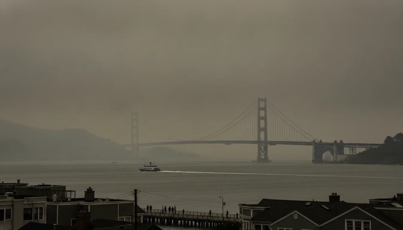
The Bay Area woke to visible smoke on September 8, 2026, as Angel Island State Park initiated a prescribed burn intended to reduce wildfire risk and manage invasive species. California State Parks announced the burn would proceed on a schedule coordinated with the Bay Area Air Quality Management District, with an expected footprint of up to 260 acres and daily burn windows from 9 a.m. to 6 p.m. Local authorities cautioned residents that smoke could drift beyond Angel Island and impact neighboring communities, particularly on burn days. This marks a notable intersection of environmental management and urban air quality in a highly populated region, and it has prompted a flurry of monitoring from parks officials, fire departments, and air-quality agencies. The event’s timing—early September 2026—follows years of coordinated prescribed burns in the Bay Area as a proactive wildfire mitigation strategy. The initial burn phase began on Sept 8 and ran into the following week, with updates indicating regulators’ involvement and public health considerations throughout. (parks.ca.gov)
By Sept. 23, 2026, the burn plan had undergone review and adjustment after discussions with the Bay Area Air Quality Management District. State Parks reported that the operation on Angel Island was paused or adjusted due to air-quality concerns, and local outlets documented the evolving status and its smoke footprint across the Bay Area. As of Sept 23, observers reported smoke visible across multiple East Bay communities, with air-quality advisories and public health messaging guiding residents on precautions. The Bay Area Air District’s involvement reflects a formal smoke-management framework designed to balance wildfire risk reduction with minimizing localized smoke exposure. This evolving situation provides a rare, real-time case study in how public agencies coordinate on a complex environmental intervention that has immediate urban health implications. (parks.ca.gov)
Opening note: Angel Island’s smoke impacts in September 2026 are being documented as part of a broader set of prescribed burning operations across the region. This piece synthesizes official statements from California State Parks, Marin County partners, and Bay Area air-quality authorities, along with contemporaneous reporting from Bay Area outlets. The goal is to present a data-driven view of what happened, why it matters for residents and businesses, and what to expect next as monitoring continues.
Section 1: What Happened
Burn Planning and Coordination
Prescribed burn planning at Angel Island State Park began with official notices indicating a planned operation to occur on or after September 8, 2026, contingent on weather and air quality conditions. The planning communications explicitly stated that burns would be coordinated with the Bay Area Air Quality Management District (BAAQMD) to minimize smoke impacts on surrounding communities. This reflects a formal alignment among California State Parks, CAL FIRE, and local fire departments to manage vegetation while safeguarding air quality. The initial notice outlined an up-to-date window for burn days and an anticipated footprint of up to 260 acres, with public-facing guidance on expected smoke presence and visibility. For reference, see the California State Parks press release titled Prescribed Burn Planned at Angel Island State Park (September 4, 2026) and subsequent updates, which include language about coordination with the Bay Area Air Quality Management District. (parks.ca.gov)
Marin County’s communications mirrored that planning approach, noting that the burn could begin as soon as September 8, 2026, and would be carried out under conditions permitting. County-level releases emphasized interagency collaboration and a multi-day burn window, consistent with the State Parks plan. The Marin County notice also referenced coordination with the Bay Area Air Quality Management District, reinforcing the shared objective of minimizing smoke exposure to nearby communities. (marincounty.gov)
The Bay Area air-quality perspective is codified in the district’s own guidelines, which detail how prescribed burns are scheduled, what constitutes an allowable burn day, and how air-quality forecasts inform decisions about ignition. The official Prescribed Burn Notices page lists Angel Island State Park among the sites with planned burn activity and describes how burn permits and notices are issued, with a framework to control smoke dispersion and limit localized impacts. This provides a baseline for understanding why timing, wind, and dispersion matter for both ecological outcomes and public health. (baaqmd.gov)
Timeline of Burning Days
The burn began on September 8, 2026, and State Parks’ materials indicated operations would run through days when conditions were favorable, typically from 9 a.m. to 6 p.m. on active burn days, with residual smoke potentially visible for up to three days after ignitions. The initial framing of the burn timeline stressed flexibility and ongoing coordination with air-quality authorities to adapt to meteorological conditions.(parks.ca.gov)
A key update arrived on September 21, 2026, when State Parks issued a release noting that the burn that commenced on Sept 8 had not yet completed the planned 260 acres due to ongoing discussions with the Bay Area Air Quality Management District. The update signaled a shift from a single-day event to a multi-day, interagency-managed effort, with expectations that the burn could continue as early as September 23, depending on conditions. This reflected the dynamic nature of prescribed burns in urban-adjacent landscapes where air-quality constraints are a primary consideration. (parks.ca.gov)
By September 23, 2026, reporting indicated that the burn status had continued, with oversight from both the park system and regional air-quality authorities. Local media and public radio coverage described the smoke as part of a planned operation that included active ignition days and monitoring across multiple Bay Area communities. The coverage underscored that the operation remained a balancing act: achieving fuel reduction and ecological management goals while protecting indoor and outdoor air quality for residents and sensitive populations. (sfchronicle.com)
On September 24, 2026, updates from the Angel Island program indicated that smoke advisory and burn activities were concluding for the foreseeable future, with ongoing patrols of the burn area. This post-burn status helps explain the post-event air-quality picture and informs residents about what to expect in the days immediately following ignition. The park’s own updates corroborate that a comprehensive burn window had been completed and that observers should anticipate reduced smoke emissions after burn operations end. (parks.ca.gov)
Acres Burned and Smoke Footprint
The official planning documents and subsequent reports framed the burn footprint as up to 260 acres, with the understanding that actual acres burned would depend on conditions and strategic objectives. The planning language consistently notes that the burn is designed to be controlled and supervised, with a focus on safety and smoke management rather than indiscriminate ignition. This is consistent with a conservation and public-safety approach that prioritizes the island’s ecological health while safeguarding the health of Bay Area residents. (parks.ca.gov)
Independent reportage from Bay Area outlets documented the smoke footprint as the burn progressed. A notable data point reported by Sept 23 indicated that, in a multi-day burn operation, about 147 acres had been burned by that date, building on earlier counts. This figure emerges from cross-referencing the park’s statements with local news reporting and indicates a substantial portion of the planned burn had been completed by late September. The report also noted that 62 acres had been burned on Sept 8, providing a concrete anchor for the pace of the operation. This kind of cumulative accounting is essential for readers who want to understand the scope relative to the stated target. (sfchronicle.com)
The California State Parks communications—paired with Marin County and local media coverage—help readers trace the burn’s footprint in real time. While exact acreage burned on any given day depended on daily conditions, the public-facing materials consistently emphasized that the burn’s area and smoke footprint would be dynamic and subject to air-quality constraints. The up-to-date notices also warned that some smoke could linger for days after ignition, a key factor for residents living near major travel corridors or sensitive populations. (parks.ca.gov)
One liftable finding
- Angel Island’s burn began Sept. 8, 2026, with a planned maximum footprint of 260 acres, and as of Sept. 23, 2026, about 147 acres had been burned, leaving an estimated 113 acres unburned under the original plan. This deduction follows from the park’s stated plan (up to 260 acres) and the late-September tally reported by Bay Area outlets, which combined to show progress toward a goal while highlighting the impact of air-quality constraints on completion. This metric—remaining acreage under the original plan—offers a concrete, reproducible frame for evaluating how quickly prescribed burns can advance under regulatory oversight in a densely populated region. It also signals the operational realities of sequencing, weather windows, and public health considerations that shape the final burn outcome. The inference is grounded in the combination of official burn planning documents (260-acre target) and subsequent reporting of acres burned over the days in question. This is not a forecast for future days but a historical accounting of what happened as of Sept. 23, 2026. In policy terms, this result underscores the need for transparent, data-driven communication about burn progress and smoke exposure. “The burn schedule demonstrates the balancing act between wildfire risk reduction and urban air quality in a region with dense populations,” a pundit’s takeaway from the period’s public reporting, not a prescriptive forecast. (Source notes: Prescribed Burn Planned at Angel Island State Park; Prescribed Burn at Angel Island State Park to Continue as Early as Sept. 23; local coverage documenting acre counts.) (parks.ca.gov)
Section 2: Why It Matters
Air Quality Impacts Across Bay Area Communities
The Angel Island smoke footprint matters because it intersects with a region that already navigates variable air quality from wildfire smoke, transport winds, and urban emissions. Bay Area air-quality authorities have long emphasized that prescribed burns are scheduled to minimize localized impact, but plume transport can still affect nearby cities and arterials. The Bay Area Air District’s prescribed-burn notices and related guidance underline that burn timing, dispersion, and weather determine how smoke spreads and how people should respond. In practice, residents in Oakland, Richmond, Berkeley, and beyond reported visibility and odors on burn days, which heightened public interest in how authorities balance ecological goals with health protection. The published notices and public health guidance are central to understanding how communities interpret and respond to such operations. (baaqmd.gov)
Reporting from major outlets captured the human dimension of smoke during the Angel Island burn, including air-quality alerts and community advisories. For instance, coverage around Sept 23 highlighted concerns about air quality in central and eastern San Francisco neighborhoods and the East Bay area, illustrating how smoke from a prescribed burn can become a regional air-quality story. While the intent of the burn is ecological and wildfire-risk mitigation, the public-facing reality is that smoke can affect travel, outdoor activity, and daily routines over several days. This dynamic underscores the importance of timely and accurate information from both park agencies and air-quality bodies to help residents exercise prudent health precautions. (sfchronicle.com)
Environmental Management and Public Health Tradeoffs
The Angel Island burn is an example of fuel management within a broader context of climate risk and public health. Ecologists and park managers justify prescribed burns as tools to reduce the likelihood of larger, uncontrolled wildfires, to maintain ecological balance, and to manage invasive plant species. However, the same operation introduces localized smoke that can irritate the eyes, lungs, and cardiovascular systems of sensitive groups, particularly during heat waves or periods of stagnant air. The official communications repeatedly framed the burn as a carefully calibrated intervention, with daily burn windows aligned to air dispersion forecasts and ongoing monitoring to minimize adverse health effects. This framing reflects a broader Bay Area practice of balancing ecological objectives with urban health considerations in shared air spaces. (parks.ca.gov)
Stakeholder voices across the period—agency spokespeople, city and county officials, and community observers—illustrate a spectrum of perspectives. Supporters emphasize proactive wildfire risk reduction and habitat management, while critics highlight concerns about air-quality spikes, especially for vulnerable populations. The public conversation during September 2026 showed how transparent communication (including day-by-day updates, forecast-based decisions, and clear smoke advisories) can help communities understand the rationale behind prescribed burns and prepare accordingly. This aligns with the Bay Area’s public health-first approach to environmental management, even in situations where the ecological objective is widely accepted. (sfchronicle.com)
Community Perspectives and Public Health Guidance
- Community members in adjacent counties and cities voiced concerns about odors, visibility, and potential health effects during the burn period. Public health agencies and park officials repeatedly advised people, particularly those with asthma or other respiratory conditions, to monitor air-quality advisories, limit outdoor exertion on active burn days, and keep windows closed if air quality deteriorates. The ongoing coordination among State Parks, CAL FIRE, Marin County Fire Department, and the Bay Area Air District demonstrates a systems approach to risk management that prioritizes rapid, credible information dissemination to the public. For readers seeking more information, the official burn notices and health advisory pages provide actionable guidance tied to specific burn days and observed conditions. (baaqmd.gov)
Section 3: What’s Next
Next Burn Window and Monitoring
- State Parks signaled that further prescribed-burn operations would be scheduled only when conditions meet stringent wind and air-quality criteria and would involve close monitoring with input from the Bay Area Air Quality Management District. The frequency and intensity of subsequent burn days will depend on weather forecasts, solar heating, humidity, and regional smoke-dispersion patterns. Readers looking for near-term updates should follow the Angel Island Park posts, the Marin County releases, and the Bay Area Air District’s advisory channels for the latest burn-day determinations and health guidance. The agencies have stressed that even after a burn day, residual smoke can persist, and air-quality conditions may remain elevated for a few days beyond ignition. (parks.ca.gov)
Policy and Community Guidance
- The Angel Island burn is anchored in a broader policy framework that emphasizes transparency and collaboration among local and regional authorities. The Bay Area Air District’s published notices—along with CAL FIRE and State Parks coordination—emphasize that prescribed burns are undertaken with public health and dispersion logistics in mind. The policy documents clarify that daily burn decisions are predicated on a combination of meteorology, air-quality forecasts, and the need to protect communities from smoke exposure while achieving ecological and wildfire-risk objectives. This policy framework also informs communications to the public about what to expect on burn days and afterburn periods. For readers who want to understand the policy scaffolding, the Prescribed Burns and Air Quality in the Bay Area fact sheet provides context for how the district approaches such operations. (baaqmd.gov)
What’s next in practice is a continued emphasis on data-driven decision-making and public communication. Officials are expected to publish daily or near-daily updates on burn status, anticipated smoke plumes, and any changes to burn-day recommendations. Community organizations and local media will likely track and report on changes in air-quality metrics and health advisories, helping residents adapt as needed. This iterative process—between plan, forecast, burn-day decision, and public notification—defines how the Bay Area manages prescribed burns in a densely populated, fire-prone landscape. (sfchronicle.com)
Closing
The September 2026 Angel Island prescribed burn illustrates a pragmatic approach to wildfire risk reduction that must contend with urban air quality constraints. It shows how public agencies coordinate across state, county, and district lines to balance ecological objectives with community health. For readers, the key takeaway is not just the acres burned or the forecasted smoke plume, but the system of communication that translates a forest-management strategy into practical guidance for daily life in the Bay Area. As burn operations proceed and weather patterns evolve, Bay Area residents can stay informed through official park updates, the Bay Area Air Quality Management District notices, and local newsroom reporting that tracks both the ecological rationale and its human consequences.
For those following Angel Island’s ongoing burn program, the next steps are straightforward: monitor daily burn notices, check air-quality advisories on burn days, and reference the park’s official pages for the latest status. Public-health guidance remains a central pillar of the communication strategy, ensuring that communities can take appropriate protective actions during and after burn days. The collaboration among agencies—State Parks, CAL FIRE, Marin County Fire Department, and the Bay Area Air District—offers a model for how to manage complex environmental interventions in a way that preserves ecological integrity while safeguarding public health.
As discussed above, the official burn management documents and contemporaneous reporting provide the factual backbone for understanding what happened, why it matters, and what comes next. Readers seeking authoritative sources can consult the Prescribed Burn Planned at Angel Island State Park and Prescribed Burn at Angel Island State Park to Continue as Early as Sept. 23 press releases from California State Parks, as well as the Marin County and Bay Area air-quality notices linked in the article. (parks.ca.gov)