
SAFER Bay Project Approval Moves Forward
Get a neutral, data-driven update about the SAFER Bay Project approval, focusing on shoreline resilience efforts in the San Francisco Bay Area.
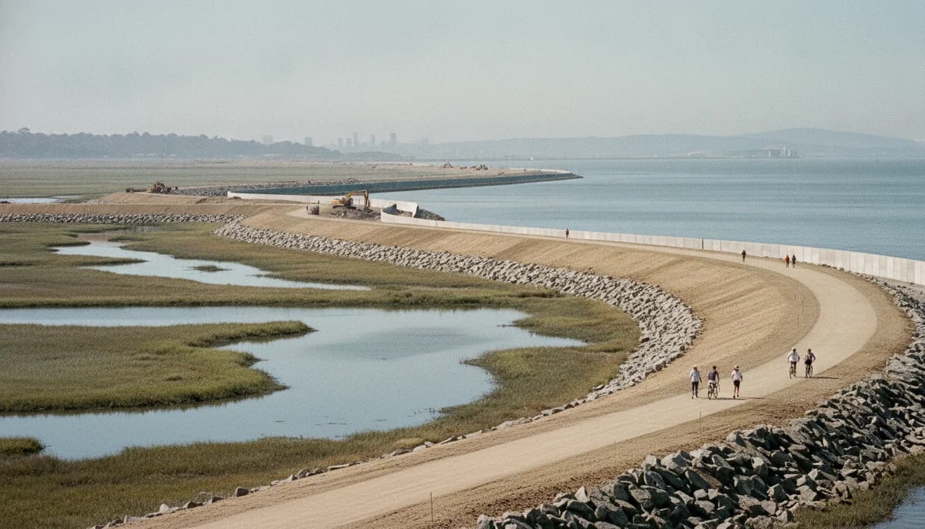
The San Francisquito Creek Joint Powers Authority (SFCJPA) has taken a pivotal step in coastal resilience with the SAFER Bay Project approval process advancing toward final CEQA milestones. The project, aimed at protecting critical infrastructure and shoreline habitats around East Palo Alto and Menlo Park, is positioned as a multi-benefit effort to shield communities from tidal flooding and rising seas while improving public access and habitat restoration. This SAFER Bay Project approval marks a milestone in Bay Area resilience planning, signaling a move from feasibility and design toward permitting, construction planning, and broader regional implementation. The decision was publicly confirmed in May 2026, underscoring the importance of coordinated action across multiple jurisdictions and funding sources as Bay Area communities confront climate risks. The move matters because it signals a clear path to protecting essential water and energy infrastructure serving hundreds of thousands of residents and businesses, while aligning with regional shoreline adaptation strategies. The immediate impact includes advancing environmental review documentation and preparing for the next design and permitting phases, with a focus on integrating nature-based approaches alongside engineered levee protections. The SAFER Bay Project approval is also a touchstone for Bay Adapt Joint Platform collaboration and the funding ecosystem that underpins major regional flood protection investments. (sfcjpa.org)
What Happened
Board action and CEQA milestone
The SFCJPA Board certified and approved the SAFER Bay Environmental Impact Report (EIR) on May 28, 2026. The Notice of Determination was subsequently filed with San Mateo County on May 29, 2026, and CEQA Clearinghouse, marking a formal regulatory milestone for the project. This action follows a programmatic EIR framework for the entire Bay Area project footprint in San Mateo County, with project-level detail for East Palo Alto and for tidal restoration elements such as ponds R1, R2, and SF2. The board action and Notice of Determination are central to unlocking subsequent phases, including permitting and construction planning. The official EIR package includes the FEIR, the Draft EIR, and the Response to Comments Document. The decision, and the related documentation, reflect a careful, data-driven assessment of environmental effects and mitigation commitments. (sfcjpa.org)
Project scope and geography
The SAFER Bay Project is described as a multi-benefit, multi-jurisdictional collaboration designed to protect communities and critical infrastructure from sea level rise and tidal flooding while enhancing habitat and public recreation. The project’s reach spans East Palo Alto and Menlo Park, with a featured emphasis on protecting roughly 3.7 miles of shoreline in Menlo Park alone, including areas like the Bayfront Expressway Reach, the Tech Campus Reach, and the Substation and Marsh Restoration Reach. This reach-based structure enables the team to pair engineered levees and flood walls with nature-based restoration and habitat improvements, allowing for flexible adaptation across different shoreline conditions. In Menlo Park, the design work is organized into these three reaches, with ongoing public engagement to shape components such as trails and Bay Trail access. The EIR process is designed to support a long-term, climate-resilient shoreline that preserves essential services and preserves or expands public access to the Bayfront. (menlopark.gov)
Funding and governance
Funding for SAFER Bay has come from a mix of state, federal, and local sources, underscoring the project’s regional significance and cross-agency collaboration. The SAFER Bay effort has previously benefited from grants to advance engineering, design, environmental documentation, regulatory compliance, permitting, and public outreach. Notably, the project has drawn support from the Federal Emergency Management Agency’s Building Resilient Infrastructure and Communities (BRIC) program and Hazard Mitigation Grant Program (HMGP), as well as the San Francisco Bay Restoration Authority’s Measure AA. The California Department of Water Resources has provided support through Proposition 84 funding, complemented by local matches from East Palo Alto and Menlo Park. In addition, the City of East Palo Alto has secured CalOES/FEMA HMGP funding, with a local match to support Phase 1 planning and design. The SAFER Bay project has also engaged in ongoing coordination with Bay Area partners, including Bay Adapt Joint Platform and OneShoreline initiatives, to ensure consistency with regional resilience planning. These funding streams collectively enable the EIR development, the continued design work, and the eventual construction phases. (sfcjpa.org)
Environmental review timeline and public engagement
Key milestones in the SAFER Bay environmental review timeline include the Draft EIR release in December 2025, followed by the Final EIR in May 2026 and the subsequent Notice of Determination. The project’s public engagement strategy has included public meetings, presentations, and outreach through community partnerships to explain levee designs, habitat restoration options, and Bay Trail improvements. Public engagement has involved community-based organizations and local stakeholders to reflect a diverse set of priorities, from flood protection to habitat restoration and recreational access. The final EIR package and its accompanying documents provide the foundation for the next steps in permitting and design, ensuring that regulatory requirements are met while enabling communities to participate in shaping the final project details. (menlopark.gov)
A note on design approach and regional alignment
The SAFER Bay Project adopts a mixed approach that combines engineered flood protection with nature-based solutions, consistent with Bay Area shoreline resilience thinking. The project aligns with the Bay Adapt Joint Platform and OneShoreline efforts, which coordinate across the nine-county Bay Area to advance shared resilience objectives. This alignment ensures that SAFER Bay’s approaches—ranging from living shorelines to elevated levee protections and habitat enhancements—fit into a broader regional strategy for climate adaptation. The project is seen not only as a local shield but also as a model for integrating ecological restoration with flood protection in a densely populated and infrastructure-rich region. The project’s emphasis on habitat restoration and enhanced public access, in addition to protecting critical infrastructure, reflects a broad, forward-looking vision for the Bay Area shoreline. (sfcjpa.org)
Key facts at a glance
- Board action: SFCJPA Board certified and approved SAFER Bay EIR on May 28, 2026. Notice of Determination filed May 29, 2026. (sfcjpa.org)
- Project scope: Multi-jurisdictional shoreline protection and restoration across East Palo Alto and Menlo Park; 3.7 miles of shoreline protected in Menlo Park. (menlopark.gov)
- Geographic focus: Reach-based design including Bayfront Expressway Reach, Tech Campus Reach, and Substation & Marsh Restoration Reach. (menlopark.gov)
- Funding mix: BRIC, HMGP, Measure AA, California DWR, CalOES, and local matches from East Palo Alto and Menlo Park; SFBRA support noted. (sfcjpa.org)
- Next steps in process: DEIR circulated in late 2025 with final EIR adoption in 2026; ongoing design, permitting, and public engagement leading to construction planning once full funding is secured. (menlopark.gov)
Why It Matters
Protecting critical infrastructure and communities
A central motivation for SAFER Bay is safeguarding essential water and energy infrastructure that serves a broad swath of the Peninsula. In Menlo Park, the project’s protection strategy targets Bayfront and Belle Haven neighborhoods and aims to shield critical facilities such as major electrical substations and water delivery infrastructure. The SAFER Bay design criteria explicitly account for FEMA flood events, freeboard, and projected sea level rise, ensuring resilience for both residential areas and essential services. The project’s scope includes protecting substation and Ravenswood facilities that serve hundreds of thousands of customers, as well as protecting water transmission infrastructure critical to Hetch Hetchy water supply. The integrated approach makes SAFER Bay a strategic component of regional resilience planning and a signal of coordinated risk reduction across multiple jurisdictions. (sfcjpa.org)
Habitat restoration and recreation as resilience multipliers
Beyond hard protections, SAFER Bay emphasizes habitat restoration and living shoreline elements that provide ecological benefits alongside flood protection. The EIR framework notes habitat enhancements and restoration for several federally threatened and endangered species, underscoring a broader environmental justice and biodiversity objective. The project also prioritizes recreational access, leveraging Bay Trail connections to provide safe, enjoyable public spaces along the shoreline. This dual focus on infrastructure and ecology aligns with Bay Area resilience thinking that resilience is most enduring when communities have both robust protection and access to healthy ecosystems. (sfcjpa.org)
Regional coordination and funding implications
The SAFER Bay effort sits at the nexus of local, state, and federal funding streams, reflecting the complexity and scale of Bay Area resilience work. BRIC and HMGP funding packages, Measure AA allocations, and state grants from the California Department of Water Resources together form a mosaic of support that enables the design and environmental documentation necessary to move forward. This funding mix also demonstrates a model for other shoreline protection projects that require multi-jurisdictional cooperation and cross-agency financing. The project’s governance structure and funding portfolio illustrate how local municipalities can leverage regional strategies to deliver large, integrated resilience projects that cross city lines. (sfcjpa.org)
Context within the Bay Area resilience ecosystem
SAFER Bay is not an isolated effort; it is part of a broader mosaic of Bay Area resilience initiatives that include regional studies, habitat restoration programs, and shoreline adaptation planning. The project is designed to be compatible with regional frameworks such as Bay Adapt and OneShoreline, contributing to a shared vision for the Bay’s shoreline that balances infrastructure protection with habitat and public access. By coordinating with regional platforms and participating in shared planning processes, SAFER Bay reinforces the Bay Area’s capacity to implement ambitious climate adaptation projects that reflect local priorities while aligning with regional objectives. (sfcjpa.org)
Who benefits and who bears responsibility
The primary beneficiaries of SAFER Bay include residents and workers in East Palo Alto and Menlo Park, as well as the broader Peninsula communities that rely on Bay Area infrastructure for water, power, and transportation. In addition to direct protections for homes, schools, and utilities, the project’s public access improvements add recreational value and community cohesion. At the same time, the project’s cost and funding responsibilities are distributed among local governments, state agencies, and federal programs, reflecting a shared commitment to climate resilience that transcends individual jurisdictions. The risk here is ensuring that funding remains intact and permitting proceeds smoothly; the project’s success hinges on sustained coordination, transparent public engagement, and the timely execution of design and construction activities. (menlopark.gov)
A broader policy and planning impact
The SAFER Bay approval dovetails with larger policy efforts to address coastal flood risk in the San Francisco Bay region. The EIR process complements other regional planning activities, including the RSAP (Regional Shoreline Adaptation Plan) and Bay sediment and habitat restoration efforts. By integrating flood protection with habitat restoration and recreation, SAFER Bay aligns with progressive policy directions that seek to reduce risk while preserving and enhancing natural capital. This alignment suggests that the Bay Area could serve as a leading example for other coastal regions grappling with rising seas and increased tidal flooding. (bcdc.ca.gov)
What critics and supporters are watching
Supporters emphasize the project’s multi-benefit design, its potential to protect critical infrastructure, and its alignment with regional resilience planning. Critics, if raised, typically focus on cost, timelines, or potential environmental trade-offs involved in large-scale levee construction and habitat restoration. The EIR process, with its public review and comment components, provides a structured mechanism for stakeholders to voice concerns and for project teams to refine designs and mitigation measures. The final EIR adoption signal, therefore, acts as a public accountability milestone, while setting the stage for subsequent design refinement, permitting, and, eventually, construction. (sfcjpa.org)
What's Next
Design, permitting, and regulatory milestones
With the EIR approved, SAFER Bay will move into the next phases of design optimization, environmental permitting, and regulatory compliance work. The Menlo Park page outlines a multi-phase design timeline that anticipates 22 months for design and environmental documentation for specific reaches, with full project design and environmental permitting to follow. Construction would occur after full funding is secured, which remains a critical gating factor in the timeline. The ongoing PSR/PDS collaboration with Caltrans indicates a continued emphasis on right-of-way planning and potential Caltrans program funding as part of the long-term plan. These steps collectively shift SAFER Bay from a planning and assessment phase into implementation planning and mobilization, signaling a significant transition in the project’s lifecycle. (menlopark.gov)
Public engagement, design refinement, and next public milestones
Public engagement remains central to SAFER Bay’s progress. The project’s engagement strategy, including planned input opportunities and ongoing outreach through community organizations, will shape design choices for levee alignments, habitat restoration approaches, and Bay Trail enhancements. The project’s public meetings and outreach events—coupled with ongoing documentation releases—will continue to provide opportunities for residents, business owners, and community groups to participate in refining the project’s details before construction begins. As the DEIR and FEIR are further reviewed and finalized, stakeholders can expect more details on reach-specific design elements, potential mitigation measures, and anticipated environmental impacts. (menlopark.gov)
Funding outlook and financial planning
The SAFER Bay project’s funding envelope remains a central determinant of momentum. With BRIC and HMGP grants, Measure AA allocations, and DWR support, the project has diverse sources to draw upon for engineering, design, environmental documentation, and permitting. Local participation from East Palo Alto and Menlo Park continues to be a critical element, with matching funds and in-kind contributions playing a role in advancing the design process. The ongoing coordination with Bay Area partners and state agencies is essential to sustaining financial commitments, securing additional funds if needed, and ensuring a coherent financial plan that aligns with the timeline for design completion, permitting, and eventual construction. (sfcjpa.org)
What to watch for in the near term
In the near term, readers should watch for:
- Any updated design reports or supplemental documentation for Reach-specific components (Bayfront Expressway Reach, Tech Campus Reach, Substation and Marsh Restoration Reach).
- Updates from the SFCJPA and partner cities on public engagement opportunities and comment periods for subsequent permitting steps.
- The progression of DEIR-related findings into final permitting actions, and any adjustments to mitigations or habitat restoration plans based on public input.
- The status of funding commitments, including potential new grants or state programs that could accelerate design and permitting timelines.
These signals will help readers understand how SAFER Bay transitions from a regulatory milestone to on-the-ground resilience work, and how the project’s multi-stakeholder governance will manage timelines, budgets, and community expectations.
Broader implications for the SF Bay Area
The SAFER Bay Project’s approval is more than a local milestone; it reinforces a broader regional approach to climate resilience in the San Francisco Bay Area. By integrating flood protection with habitat restoration and public recreation, SAFER Bay embodies a holistic approach that other Bay Area shoreline projects may seek to emulate. The project’s alignment with regional platforms like Bay Adapt and OneShoreline demonstrates a coordinated pathway to scale resilience investments across multiple jurisdictions, leveraging shared knowledge, funding channels, and environmental review processes to address the region’s complex shoreline challenges. As the Bay Area continues to confront rising seas and more intense storm events, SAFER Bay’s ongoing development will likely serve as a touchstone for how communities balance infrastructure protection with ecological integrity and public access. (sfcjpa.org)
Closing
The SAFER Bay Project approval advances a multi-jurisdictional resilience strategy that seeks to protect critical infrastructure, restore habitats, and expand public shoreline access along the San Francisco Bay. With the EIR certified on May 28, 2026, and the Notice of Determination filed the next day, the project moves into design refinement, permitting, and funding realignment phases that will shape the Peninsula’s resilience for years to come. As design work continues and community input broadens, readers can stay informed through the SFCJPA’s News & Information channels, the City of Menlo Park’s SAFER Bay project pages, and the East Palo Alto and Bay Area regional planning platforms that track shoreline adaptation progress. These sources will offer ongoing updates on upcoming public meetings, design milestones, and funding announcements as SAFER Bay transitions from planning to implementation, with the goal of reducing risk for communities, protecting essential services, and enriching the Bay Area’s natural heritage.
Readers seeking updates can monitor the San Francisquito Creek Joint Powers Authority site for SAFER Bay project documents and notices, as well as the City of Menlo Park’s ongoing project information pages, which provide context on reach-specific design work and timelines. The broader Bay Area resilience community, including Bay Adapt, OneShoreline, and related state and federal programs, will also provide additional context and opportunities for public participation as SAFER Bay progresses.